πρότζεκτ
Προστασία οικοτόπων & βιοποικιλότητας
iSea Posidonia Mapping Corfu
€4,580 awarded
The Ionian Environment Foundation supported iSea in the critical task of mapping the Posidonia Meadows around the threatened region of the Erimitis peninsular. This area projects into a narrow body of water between the coasts of Albania and Greece (Northeast Corfu), that separates the two countries. The channel is a passage from the Adriatic Sea to the north to the Ionian Sea.
REPORT SUMMARY:
Why this survey is important:
The endemic species Posidonia oceanica is the most important seagrass in the Mediterranean Sea (Boudouresque et al. 2006)
The role of Posidonia meadows in marine coastal environments is often correctly compared to that of the forest in terrestrial environments.
By producing enormous quantities of vegetal biomass, the meadows form the basis of many food webs and this primary production is comparable to or greater than that of other high ‐ production environments.
Posidonia meadows constitute a spawning ground, a nursery or a permanent habitat for over 400 different plant species and several thousand animal species making these underwater meadows a unique biodiversity hotspot
Posidonia meadows are considered an “ecosystem engineer” as they stabilise the sediment with its roots and changes the hydrodynamic status of the sublittoral zone and protects from erosion
Crucially, Posidonia serves as long‐term carbon storage, storing carbon for millennia and hence play an active role in reducing the greenhouse gases in the atmosphere that fuel global warming
On Corfu, information about the spatial extent of the seagrass meadows is poor with only two areas having been mapped: between Othonoi island and Mathraki and from Perama to Ag. Ioannis
The main threat to these meadows is habitat degradation by the following human activities:
water pollution, construction of coastal infrastructure, modification of marine currents, fishing, invasive species and shipping;
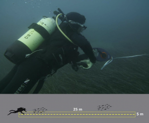
Critically, research is needed in order to assess the situation and build data on this mostly understudied area.
Findings:
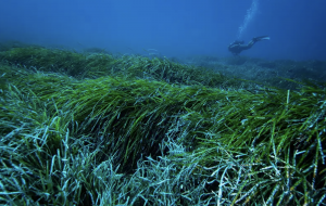
It was observed that this area consists of a healthy and undisturbed meadow, hosting a high number of different species.
Although, pristine environments do not exist today especially in coastal areas due to anthropogenic pressures, the study area was almost intact from human interference.
Species composition was high and the surveys yielded most of the expected species associated with Posidonia meadows.
It is worth mentioning that no alien species where observed, unlike most parts of the Greek seas, adding to the assumption that the meadow is healthy and intact.
The upper limit of the meadow was extremely close to shoreline starting from 0.2m depth, which is an indication of good health (Montefalcone et al. 2010).
Although seagrass meadows may be naturally fragmented by waves, currents and colonisation processes into patches of different size and form, this monitored area meadow seemed compact with only 4 patches without Posidonia in the southern bay of the study area. Furthermore, the density of the leaves was high, throughout most of the meadow.
The meadow was in a very good condition with little to no fragmented meadows in the most of its area.
Conclusion:
It becomes apparent that the protection of Erimitis bay and the management of its threats and disturbances should be highly prioritised. This is a unique and almost ‘pristine environment’, of which there are very few reamining in Greece. It must be cherished.